History
Albany History
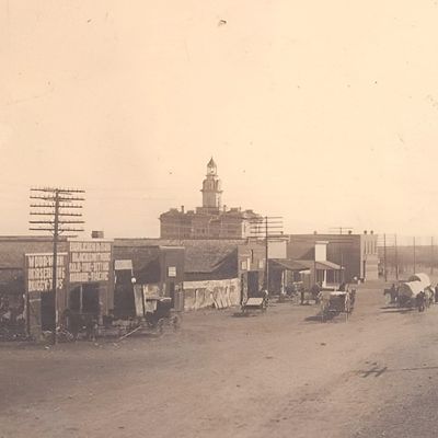
In November of 1874, residents of the newly organized county of Shackelford went to the voting booths and decided where their future county seat would be. At that time, the frontier town of Fort Griffin, also known as “The Flat”, on the Clear Fork of the Brazos River in the northeastern part of the county below the actual military fort of Ft. Griffin, was the hub of activity in the area. It was chosen as the temporary county seat until this particular election and Griffinites hoped that their town would be chosen as the permanent county seat. However, many in the county felt that Fort Griffin was too rough and rowdy to be the seat of county government with its many saloons and “houses of ill repute”, which attracted the roughest kinds of men and women to town. Conservative ranchers and farmers wanted nothing to do with this “hive of lawlessness” and proposed a new undeveloped area in the center of the county to serve as the permanent county seat. On November 8 of that year, county residents voted 54 to 39 in favor of having the county seat moved permanently from Fort Griffin to the new town in the center of the county, which was named Albany by county clerk William Cruger after his former home of Albany, Georgia. The land for the townsite was donated by Henry Jacobs.
The first order of business was to survey the townsite and sell lots. Land in the middle of the townsite was set aside for the building of a permanent county courthouse. Soon, the new town had a post office and a thriving business district with a number of hotels, dry goods stores, government offices, and, of course, a few saloons. Homes were built, a school was established, a newspaper was begun, and a church was organized. By 1881, Albany had everything a growing community on the frontier would need to survive, except a railroad. Albany had seen what had happened to other prosperous towns in the area that the Texas and Pacific Railroad had bypassed. Buffalo Gap was the county seat and major town in Taylor County until the railroad came. Instead of running farther south through Buffalo Gap, the railroad decided to run its tracks through the northern part of the county. The railroad thus helped create the new town of Abilene. Since commerce would be centered around the railroad, many Buffalo Gap citizens moved themselves and their businesses from Buffalo Gap to Abilene. Later, citizens voted to move the county seat from Buffalo Gap to Abilene. As a result, Buffalo Gap became an obsolete, declining town. The same thing occurred to the prosperous town of Belle Plain, in Callahan County. When the railroad came, county offices and many businesses migrated northward to the newer town of Baird, which was located on the railroad. Just like Buffalo Gap, Belle Plain declined afterwards. The competition between Fort Griffin and Albany was similar to these other situations. Although the Texas and Pacific, which ran east and west, would not come close to either town, another railroad, which ran north and south, could. The Texas-Central Railroad ran from Houston through Waco to its final stop in Cisco, in Eastland County, 33 miles southeast of Albany. In the future, the railroad wanted to extend its line into the Texas Panhandle and beyond. Albany hoped that the railroad would extend its line at least to Albany. Citizens convinced the railroad that the Albany area was an important shipping point for cattle and that having the railroad run through there would be most profitable. The land in Albany necessary for the railroad would be provided. In addition, citizens raised $50,000 to entice the railroad to come. Fort Griffin had hoped that the line would come through their town, but Albany’s offer was too good for the railroad to pass up. In December of 1881, the first train steamed into Albany from Cisco. After this, the competition between Albany and Fort Griffin was no more. The military fort had already been abandoned and the coming of the railroad to Albany sealed the fate of the town of Fort Griffin. Most of the remaining merchants in Fort Griffin moved their businesses to Albany to be near the railroad. Thus, Fort Griffin faded into history.
In the years following the coming of the railroad, Albany experienced dramatic growth. The town had become a very important shipping point for cattle, wool, and buffalo bones, among other things. Hereford cattle would play a big part in this growth. The first of the new breed of cattle was introduced there, earning Albany the nickname, “Home of the Hereford”. In 1884, the construction of the Shackelford County Courthouse was completed. In 1886, the area was ravaged by a severe drought, prompting a visit to Albany and nearby Hulltown by Clara Barton, the founder of the American Red Cross. During these years, the farming and ranching industry dominated the economy of Albany and Shackelford County. By 1910, that changed when the Cottle No. 1 gas well (located 15 miles southeast of Albany near Moran (formerly Hulltown) was discovered. This discovery ushered in the oil boom to Shackelford County. Wells sprung up everywhere and Albany became the hub of a growing oil industry in the area. Thousands of wildcatters and their families arrived to strike oil and get rich. Many did, but many didn’t. Nevertheless, the oil boom of the 1910’s and 1920’s made Albany grow even more, both in population and in wealth. In 1927, the city was finally incorporated. With the end of the oil boom and the stock market crash of 1929 and the following years of the Great Depression, World War II, and the Post-War years, Albany experienced the pains many other towns in the area did. During the 1950’s and 1960’s, the population declined as people flocked to larger towns and cities and the automobile enabled people to travel elsewhere to buy goods. In the 1970’s and 1980’s, Albany civic leaders and merchants worked harder to keep people home, and they succeeded. In 1978, Albany was tested by the remnants of Tropical Storm Amelia, which dropped over 20 inches of rain on Albany and the surrounding area within a 24 hour period. The flood damage was excessive and Albany received nationwide attention. It took awhile, but Albany gradually recovered. Another catastrophe also received nationwide attention in 1988 when a huge range fire erupted after a careless person burned tires in Clyde. The dry and windy March conditions enabled the out of control fire to spread quickly north into Shackelford County. The fire burned millions of acres of land and almost led to the evacuations of both Albany and Moran as the fire inched within miles of both towns before shifting in another direction. Luckily, the fire was then brought under control and put out by a blockade of firefighters from all over the country who responded. In both instances, Albany managed to stand tall in the face of adversity.
Today, Albany is a small town that has a lot to offer. Since the oil bust in the mid 1980’s, Albany has tried to find other means to keep the local economy going. Tourism has come to the forefront. Albany receives thousands of visitors each year. Some come to tour the many historical sites that Albany has to offer. Some come to tour Fort Griffin State Park north of town. One of the most noted places in Albany to visit is the Old Jail Art Center. Housed in the original county jail, the center was conceived by citizens as a place to display works of art. The center became so popular, that an expansion was constructed in 1984. Still that proved to be not enough space. In 1997, another addition was added, doubling the size of the center. This newer addition was added for the purpose of displaying artifacts of local history and for enhancing the Robert Nail Archives, a collection of historical material related to Shackelford County, named after a local historian and playwriter who compiled the material and who was instrumental in saving the jail from being demolished. Robert Nail also was responsible for another of Albany’s tourist attractions, its most famous, “The Fort Griffin Fandangle”. Created as a senior class play in 1938, the Fandangle has evolved into a yearly Albany tradition. Thousands come to Albany each year to see the locally produced and directed outdoor musical, which tells the story of the settling of Shackelford County and the founding of the military outpost and frontier town of Fort Griffin. It is ironic that the town that beat out Fort Griffin for the railroad in 1881 would be the one keeping its memory alive in song and dance. This goes to show how proud Albany is of its frontier heritage.

Fort Griffin History
One of the most important of Texas’ frontier defenses, this historic landmark in northeastern Shackelford County was first acquired as a Texas State Park in 1936. In 1968, management of the site was transferred to the Texas Historical Commission and re-designated as a State Historic Site on May 17 that year.. On the same date, four other historic sites were also acquired: Fort Richardson in nearby Jack County, Fort McKavett in Menard County, Fort Lancaster in Crockett County, and Fort Leaton in Presidio County.
The garrison was originally established as part of a new “Western Line” of defense in 1867, along with Forts Richardson and Concho, in response to long and anguished outcries from settlers for more and better protection from the Indian menace along the Texas frontier.
On July 31, Lieutenant Colonel Samuel D. Sturgis and four companies of the Sixth Cavalry located the new post on a high plateau, southwest of a bend of the Clear Fork of the Brazos. At first designated Camp Wilson, special orders the following February changed the name of the garrison to Fort Griffin, after General Charles Griffin, former Commander of the Department of Texas.
Militarily speaking, Fort Griffin came to be a place of great importance on the Texas frontier, as it was situated along the trail followed by Comanche war parties on their raiding sorties into Mexico. There were two other factors of a non-military nature that caused Fort Griffin, and the town which “boomed” on the flat below, to become one of the most colorful spots on the Western Frontier. It was located on a direct line from South Texas to Dodge City, Kansas. This route, which was used extensively in the days of the great cattle drives, was known as the “Western” or “Dodge City Trail,” and approximately six million of the estimated twelve million cattle and horses which went north between 1867 and 1885, passed through Fort Griffin. Secondly, Fort Griffin sat on the fringe of the southern bison range, and when hides were found to have a high commercial value, the village below the post on “Government Hill” afforded a natural market.
It was intended originally that all buildings on the post would be permanent stone structures. Since construction of stone buildings would require a year or more, immediate preparations were made for temporary quarters. Rude log structures, “picket” huts (posts set vertically side by side in ground trenches and chinked with mortar), tents, and rough frame buildings with earth and canvas roofs were hurriedly erected as provisional shelter. In the end, however less than half-a-dozen of some 90-odd structures had ever been built wholly of stone.
Fort Griffin was never a glamorous post but it retained a crude and temporary appearance until the time of its abandonment in 1881. As late as 1874, General of the Army Philip Sheridan received a message from General Christopher Augur, Commandant of the Department of Texas, declaring that Fort Griffin “is unfit for human habitation.” It did, however, assume a most active and important role in providing protection for settlers and in ultimately purging the West Texas frontier of the menace of the Kiowa and Comanche raiders.
There was a marked increase in Indian depredations during the early days of 1871. A total of fourteen persons were murdered that spring and Salt Creek Prairie, about mid-way between Forts Griffin and Richardson, bore the brunt of these atrocities. The brutal Salt Creek Massacre (Warren Wagon Train Massacre) in May of that year, served as the last straw in convincing the U.S. Government that it needed to alter their relaxed policy with regards to leaving the control of the hostile Indians in the hands of lenient Reservation Agents.
General W.T. Sherman, on an inspection tour of the frontier, barely missed being a victim of the Salt Creek raid. At this point, Sherman (who had previously been skeptical of the ferocity of Indian raids) immediately withdrew earlier instructions which allowed the hostiles sanctuary on their reservations and gave explicit orders to his field commanders for “all-out” war against the offenders. A new day in Indian warfare on the Southern Plains had dawned.
A young and vigorous officer with a brilliant Civil War record, Colonel Ranald S. Mackenzie, commanding the 4th Cavalry at Richardson, was given a free rein in his pursuit of the renegades - to the point of following them directly to the reservation at Fort Sill in Indian Territory, if necessary. Campaigns conducted by Mackenzie over the following three and one-half years would culminate at the Battle of Palo Duro Canyon which would forever break the power of the Southern Plains Indians.
From the beginning of these campaigns in May of 1871, when Mackenzie was directed to pursue the murderers of the Warren Wagon Train teamsters, Fort Griffin contributed notably. Major W.H. Wood, then commanding the post, was ordered to take 150 cavalrymen and cooperate with Mackenzie in the pursuit of the renegades. In the fall of that year, the first of a series of massive campaigns against the Staked Plains tribes in the Panhandle was underway. Again Fort Griffin troopers were thrown into action, as were the Tonkawa Indian Scouts who lived on Collins Creek below the fort. These Tonkawa Indians performed stellar service for Mackenzie during his Panhandle campaigns and contributed immeasurably to his successes.
Mackenzie and units of his 4th Cavalry from Griffin, Richardson and Concho relentlessly pursued their quarry over the next 36 months - never killing many Indians but destroying their lodges and equipment and exhausting their ponies - waging a terribly effective war of logistics. During this entire period Mackenzie and his troops were supplied out of Fort Griffin. The fort itself and an abandoned post just up the river, Camp Cooper, were also used as places of rest and relaxation between campaigns.
At the beginning of Mackenzie’s Red River Campaign in August, 1874, Negro troopers of the Ninth Cavalry, dubbed by the Indians “Buffalo Soldiers,” stationed at Fort Griffin under the command of Lt. Colonel George P. Buell, contributed a brilliant success. The engagement resulted in two Indian dead and the destruction of near six hundred lodges, tons of supplies and equipment, and scores of horses.. On September 28, 1874, the Indians suffered a complete defeat at the Battle of Palo Duro Canyon. This action virtually ended the Red River Wars and the threat of future depredations by Indians of the South Plains.
The town of Fort Griffin which sprang up on the banks of the Clear Fork below the fort and came to be known as “The Flat” or “Buffalo Town” is surely a classic example of the roaring frontier town so typical of the West. It boasted “a man for breakfast every morning,” and its streets were thronged with every type of humanity imaginable: buffalo hunters, soldiers, drovers, gamblers, saloon girls, surveyors, outlaws, clerks, merchants and ranchers. “The Flat” was frequented at various times by such colorful characters as “Doc” Holliday, “Big Nose” Kate Elder, John Selman, “Bat” Masterson, Lottie Deno (The Poker Queen), and other notorious types.
The more stable element of the area populace attempted to bring a civilizing influence to the frontier disorder. They succeeded in some small degree - but the final knell was sounding for Fort Griffin. The fort on the hill was abandoned in May of 1881 when Captain J.B. Irvine and Company A of the Twenty-second Infantry retreated to Fort Clark; the cattle drives were ending; by 1879 the buffalo had been all but exterminated; and in 1882 the railroad had gone to Albany and that town had also been named the county seat. The post on “Government Hill” and the town on the flat alike, began to wither and die. All that now remains of the colorful era which flourished there on the Clear Fork are the few stone skeletons that guard the secrets of those early turbulent days on the northwest Texas frontier.
Shackelford County History
The first white men to see our area were probably the Spanish explorers near the time of 1787. As early as 1829 an amazingly accurate map was drawn of this region under the direction of Stephen F. Austin.
The first step toward settlement of North and West Texas was the establishment, during the Republic years, of the Peters Colony, later called the Texas Emigration and Land Company, which opened vast areas of Texas to immigrants from outside Texas. The land was then laid off into 320 acre tracts, and Shackelford County was created in 1858 and attached to Bosque County. It was named for Dr. John (Jack) Shackelford who personally furnished the clothing and arms for more than seventy-five Red Rovers who fought many Texas Independence battles. They were murdered at Goliad, but the doctor, also in the massacre, was spared by the Mexicans because of his medical skill and later wrote an excellent account of the battle.
Soldiers arrived at a point on the Clear Fork west of the Shackelford line and set up a fort in late 1851, Fort Phantom Hill. An Indian agent from Ohio, Jesse Stem, came to Clear Fork country and started a farm and an Indian agency on the river in 1852. Near this site four years later another pre-Civil War army post called Camp Cooper was established, and nearby was a Comanche Indian Reservation. Although these events did not take place inside our county boundaries, they are the first recorded settlement of men in our area.
Shackelford was attached to Palo Pinto County in 1860. During this Civil War period families forted up in groups along one or another of the streams throughout the Clear Fork and Hubbard Creek areas. Some four or five of these are known to have existed.
Following the war, Fort Griffin was established in Shackelford Co. by the U.S. Army nine miles below the old Camp Cooper site on the same river, the Clear Fork of the Brazos. Having endured countless Indian depredations during the war, people moved near the fort for protection. Simultaneously the land around Fort Griffin was being sold, principally by three men—D. M. Dowell of Louisville, Kentucky, and Capt. Wm. G. Veal and T. E. Jackson of Texas; and shortly afterwards a town grew up at the foot of military hill. In 1871 Gen. Ranald Mackenzie organized 600 troops at the old Camp Cooper site and started his drive against the Indians, eventually bringing freedom from their constant harassment to the settlers. The Mackenzie Trail resulted from these sweeps through Northwest Texas and opened that area to civilization.
Then in May of 1874 our county was attached to Jack Co. for judicial purposes. That fall a group of 174 determined pioneers petitioned the Jack County Court to become a separate legal entity, and by September Shackelford had its own officers. Fort Griffin served as temporary county seat until the election in November which determined that the NE quarter, section No. 1 of the Blind Asylum Survey would be the permanent county seat, then only a mail station, by a vote of 54 to 39 over Fort Griffin. W. R. Cruger named the new location Albany for his home of Albany, Georgia, and a picket courthouse was built the following year. Henry Carter Jacobs, the county’s first sheriff, gave the land for that courthouse and the land for many of the business and residence lots, too.
Until 1878 the people of this county were engaged primarily in cattle raising as thousands of bovines grazed the prairie without restriction from fences, marked by the brands of their owners. But that year the first flock of sheep was driven into the county, and sheep raising became very popular. Four years later 60,000 head of sheep were quartered within the county. Cattle drives were numerous as the longest trail on this continent, the Western Cattle Trail, and continued for fifteen years with the large herds of Longhorns passing Ft. Griffin north to Kansas and Nebraska. For a brief time buffalo hides also boosted the economy of this area. Traders, skinners, and hunters used Griffin as a supply point and as a watering spot, recreation area, or trading center. Gamblers, cowboys, traders, women, soldiers, and decent folks all saw Griffin in its heyday. Even the early day preacher, the circuit rider, was there.
After $50,000 had been raised as an incentive to the company, the Texas Central Railroad chugged into Albany in 1881 by-passing Ft. Griffin. The fort closed that year, too, and soon Griffin was no more the most important business center west of Ft. Worth. Its decline was rapid, but Albany was growing. The railroad arriving from Cisco gave other areas in the SE part of the county needed support, resulting in the birth of a new community, Hulltown, named after Swope Hull, a storekeeper. The name was changed to Hicks for a short while until Moran received its permanent name in 1892. The train was also responsible for the growth of Sedwick (a small farming community no longer in existence between Moran and Albany).
Raising beef cattle was the basis for our county’s livelihood, but sheep raising continued to be popular, and in 1886 500,000 lbs. of wool were marketed in Albany. Cotton farming sparked the growth of another community, Newcomb, between Breckenridge and Albany, and gins were built in Albany, Moran, Sedwick, and Newcomb. But a terrible drought started in the late ‘80s which practically eliminated sheep from the county and hurt the struggling farmers and small ranchers. Had it not been for the railroad bringing a car of water daily, Albany would surely have been abandoned. The train’s terminus was extended to Stamford in 1900.
Many stock farmers moved into the county about the turn of the century and attempted to make a living for their families on small arced tract. But some harsh lessons of this land, droughts and grasshoppers, made this form of living difficult if not impossible. Many were forced to sell or move on.
Soon after the advent of the 20th century, “screaming like a banshee”, the Texas Company Cottle Well No. 1 was brought in near Moran in 1910. The leasing of land in Shackelford County for drilling purposes continued slowly until 1921 when Ed A. Landreth discovered the Caddo lime. Ibex was born, and the world’s largest gasoline absorption plant at that time was built. Shackelford County became oil territory even more when Roeser and Pendleton entered into this area’s play in 1926 and brought in the 1,000 barrel discovery producer on the Cook Ranch northwest of Albany. Later the discovery of the Ivy Field in the northwest corner of the county opened that area for exploration.
In the middle ‘40s the Sanders Field, producing from the Ellenburger lime, initiated the leasing of most county land to major oil companies, and the new deep exploration brought several drilling companies to Albany. Both shallow and deep drilling continued through the ‘50s. In the ‘60s the Mississippian reefs were discovered in the northeast part of Shackelford Co. bringing another wave of activity. The demand for energy in the ‘70s has brought continued interest with the result that Shackelford Co. has led in discoveries in the West Central Texas area for the past several years.
Oil production and discovery, cattle raising, and farming continue to be our major industries.
What a romantic history; what a worthy heritage.